Curaçao Delight: Going Dutch
/
"Life is what happens while you are making other plans" the adage goes. I believe there is much truth to this. Indeed, many of our travels, mishaps, and adventures happened in this vein: hiccups in our master plan, a curve in the road, a fly in the ointment. Consequently our plans would change, sometimes drastically. It was in such a framework that we unexpectedly discovered and lingered on the delightful island of Curaçao, one of the "ABCs" (Aruba, Bonaire, Curaçao) in the Dutch Antilles—thanks to a sudden whim.
We had just spent two months sailing around and exploring a good portion of Cuba. We finally set sail from Santiago, bidding a final farewell, and headed due east to Martinique. Three years earlier we were only able to spend a very brief amount of time in Martinique while sailing up from South America to Florida. It seemed like a good idea to go back and visit more of this French island this time around.
Sailing east from Cuba in the Caribbean to islands of the West Indies is not a piece of cake. Battling strong trade winds head on means an uncomfortable ride with choppy seas and a strong counter-current. Such conditions translate to a lot of water crashing on deck. Even though the air temperature was hot this April 1989, we still had to keep the hatches closed tight while sailing, making for stifling and oppressive living conditions. The going was slow and tedious, and we didn't make much progress on an average day's sail. After a long slog off the coast of Haiti, we decided to break up this very slow passage with brief day sails and several stops along the Dominican Republic coast. Our last anchorage was in the delightful village of Boca Chica. However, by the time we were ready to leave this spot, we had pretty much given up the idea of continuing on to Martinique. We did give it one last old "college try," heading out to sea once again, with a course due east. After a few hours of, once again, buttressing the relentless trade winds head on, making little headway after 24 hours, we decided that enough-was-enough. At this rate it would take us forever. Why punish ourselves? No one was forcing us to go to Martinique. No one was waiting for us there. Martinique would just have to wait for some other time—or not. So where to? Michel explored setting us on a different course that would be a more comfortable "reach" and also faster. Then with this new compass heading he sat at the chart table and traced where it could lead us: the island of Curaçao—south, just off the coast of Venezuela.
Huh? What? Where? Curaçao?? We knew nothing about this place. All I knew was that it was the name of a liqueur. It was never on our radar. It was never in our plans. We'd never even heard it discussed as a destination amongst our fellow cruising friends. This was a curveball. Was it lemons or lemonade? Should we go? Were the "natives" friendly? Could we just arrive like that, without visas? Did they welcome both French and Americans (Michel didn't have an American passport at the time, nor I a French one)? What did their national flag look like? We needed one for the required courtesy flag that needs to be hoisted in a visiting vessel's rigging upon arrival. Since there was no Internet in the 1980s—just books and our friends on the Ham radio network—we quickly set about researching these details in preparation of a projected landfall just four or five days away.
It turned out that visas were not necessary, and there were no peculiarities regarding customs or immigration formalities. With remnants we had on hand from the kids' old T-shirts and shorts I was able to quickly sew up something resembling Curaçao's flag. Through the Ham network we were put in touch with some cruisers currently in an anchorage onsite and that's how we targeted a spot called Spanish Water, reputedly friendly and well-equipped to serve itinerant sailors' needs.
Curaçao turned out to be a pure and unexpected delight, and the natives were indeed friendly. Michel and I loved it, our boys loved it, and we stayed for four months. Curious and captivating in our time frame, Curaçao knew its prime from the early 1600s to the mid 1800s: a hub of the slave trade and an important axe of the triangular trade routes between Europe, Africa, and the Caribbean. Important trade partnerships were also established with South America. The future governor of New York, Dutchman Peter Stuyvesant, was the government administrator in Curaçao from 1647 until 1664. At the time, the Dutch dominated shipping and trade, and their dominance was reflected in the emerging prominence of three of their colonial islands Curaçao, Bonaire, and Aruba.
Thanks to their Dutch-English-Spanish heritage, the local population today is a shining example of polyglot superiority. From simple shopkeepers, bus drivers and street sweepers, to grammar school students and business owners—all are fluent in four languages: Dutch, English, Spanish, along with their local dialect of Papiamentu. They put us all to shame.
At 171 square miles, this is a Caribbean tropical island basking in sun-blinding aqua waters that lap at white sandy beaches; it is dotted with the requisite palm trees and benefits from year-round warm temperatures. Nevertheless, the landscape is largely arid and populated with a variety of cactus, while still bordered by coral reefs, and rocky coastal ledges and cliffs of ancient lava. The national Divi-divi tree is easily identifiable due to its distinctive "wind-swept" profile, seemingly sculpted by ever-present trade winds. Then suddenly a vista is punctuated by a flight of wild parrots, or colorful iguanas and green-aqua-blue lizards scampering underfoot, while a wild donkey or two lingers off in the distance.

Curaçao is also surprisingly self-sufficient and somewhat visionary in regard to its infrastructure. Along with tourism, the island's oil refinery is also a major a mainstay of the economy, with most of the oil coming from Venezuela and most of the refined oil products exported to the United States. And while the world today debates climate warming and the depletion of the earth's natural resources, Curaçao has been ahead of the game since 1928 when the world's first, (and up until 2009 was the largest), desalination plant was installed on the island, providing all the fresh tap water for the island's needs. I can't confirm this, but when we were there, rumor had it that even the local version of Amstel Dutch beer was brewed with this water.
I was also amused to learn that the multi-colored, orange-infused Curaçao liqueur—the name which first tickled my memory upon charting a course for this island—is indeed one of the island's peculiar claims to fame. It seems that the arid climate and nutrient poor soil fostered the growth of the laraha citrus fruit, sort of a starved version of a Valencia orange, and its aromatic peel provided inspiration for this spirit. Naturally colorless, the distillers must have been inspired by their hometown colorful main street waterfront architecture. Along with the "white" or naturally clear-colored selection, Curaçao liqueurs also come in three tropical siblings: blue, green, orange.
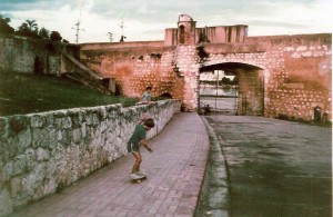
Living up to its modern reputation as a tropical island resort getaway, there are some post card beaches that serve as headquarters for a luxury resort or two. But it's the main town, the capital of Willemstad, with its curious combination of Dutch colonial architecture sporting bright and colorfully painted façades of Caribbean flair that conspire to capture a quirky storybook quaint charm of Curaçao. A wink to Holland, oddly out of place. What kind of fantasy paradise was this where real people could live and work?
Willemstad, also the main harbor and touted as the largest in the Caribbean, is mostly frequented by a regular traffic of cruise ships, freighters, and oil tankers. The waterfront street along the harbor is colorful and lively as a profusion of Venezuelan boats, known collectively as the "floating market," are tied up alongside the wharf, selling a variety of wares from produce and fish to household items. A pedestrian network of side and back streets plays host to boutiques, shops, historic and present-day government buildings and plazas, making up the fabric of a bustling hub animated by a cross section of multi-national people and a street soundtrack from the Tower of Babel.

The harbor, also known as the St. Anna Bay, bisects Willemstad, the two parts christened Punda and Otrobanda. The sectors are located opposite each other at either end of the landmark pedestrian floating bridge, the Queen Emma pontoon bridge—a sort of umbilical link to each side. Although at first impression, divvied up in half, it would seem that the city might embody a split personality. However, both areas actually interact seamlessly in a two-part harmony as pedestrians easily amble back and forth all day between the commercial and tourist-oriented Punda, and the preserved historic cottages of the residential enclave Otrobanda.
Onboard Cowabunga, however, we were a short distance—maybe 10 miles or so—from Willemstad, anchored in the calm and secluded refuge of Spanish Water. Here we found a surprising community of cruisers, several with kids the ages of ours, and we allowed ourselves to be seduced into staying for four months. Then we were Anchored in Spanish Water, Anchored to Curaçao...suite.